-
Hotels
-
By Location
- - Arenal Volcano (La Fortuna)
- - Monteverde
- - Papagayo Gulf
- - Flamingo / Tamarindo
- - Guanacaste, Liberia
- - San Jose City
- - Near International Airport
- - Cahuita & Puerto Viejo
- - Tortuguero
- - Manuel Antonio
- - Jaco Beach
- Other Locations...
Northern RegionNorth Pacific RegionCentral ValleyCaribbean CoastCentral Pacific - Category
- Budget
- Main Cities
-
By Location
- Vacations and Activities
- Where to Go
- Transportation
- Costa Rica Info
-
Maps


North Pacific Region
 The Guanacaste province is located in the Northwestern part of the country. This territory was originally part of Nicaragua, but it annexed to the country on the 25th of July, 1824.
Guanacaste is the second biggest and most populated province in the country. It limits to the north with the Republic of Nicaragua, to the east with Alajuela, to the south with Puntarenas and to the west with the Pacific Ocean.
Its capital is Liberia. Guanacaste takes the name of the national tree. Its geography is rough because of the Mountain range .Some high zones are located in the Peninsula of Nicoya. Thanks to its natural beauty, including amazing beaches and landscapes, Guanacaste has had an amazing growth in the tourism field, making it the most important economical activity in the area.
Guanacaste has Costa Rica's second international airport, and over 30 airlines have scheduled their services to Daniel Oduber International Airport.
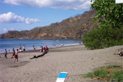
In Guanacaste, it is possible to enjoy Costa Rica’s traditions, since most of the country's folklore comes from Guanacaste. As well, this region is known for its beautifull beaches, the most famous are, Papagayo golf, Hermosa beach, Coco beach, Big Beach, Tamarindo, Flamingo, Avellanas, Brasilito, Samara, Nosara, Puerto Carrillo and many others. National parks and protected areas are also an important part of Guanacaste.
Guanacaste has 11 cantons and 47 districts. Liberia, Nicoya, Bagaces, Carrillo, Cañas, Abangares, Tilaran, Nandayure, Tilaran, La Cruz and Hojancha.
Inter-American Highway
The North Inter-American Highway crosses Costa Rica in 2 ways. This route starts in Central Park in San Jose. It passes by San Jose, Heredia, Alajuela, Puntarenas and Guanacaste. A 3 lane highway will take you from San Jose to Manolo’s (a well known restaurant near the airport, in La Garita).
There is a toll, however it's closed during peak hours.
National Refuge of Wild Fauna Peñas Blancas
It is usually confused with the town bordering Nicaragua due to its name. This refuge has 2400 hectares and is located in the southern part of the Tilaran mountain range. The elevations in this area are of 600m and over 1400m above the sea level.
These white cliffs were created to protect the flora and fauna. The Ministry of Energy and Environment (MINAE) use this money to develop infrastructures in the entire zone.
Dry season goes from January to April.
The closest town to this refugee is Miramar, an important gold mining center. It's a nice place to visit although there aren't any lodges or facilities for visitors. Camping is permitted for those adventurous travelers.
Costa de Pajaros
Costa de Pajaros (Bird Coast) is located between Punta Morales and Manzanillo. It's very famous for the many birds' species that inhabit in the area. Birds Island is less than one km from the coast, and is well known for the many pelicans and seabirds that can be observed in the island.
Las Juntas
Its full name is Juntas de Abangares; it is a small town next to the Abangares River. This place was a gold mining industry during the 19th and 20th centuries. Nowadays, it's a relaxing town full of farmers, with a growing tourism industry..
Monteverde
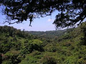
Monteverde has two cloud forests and two ecosystems as well, with warm winds from the Caribbean and cold winds from the rain forests. Its mixed climate is perfect for cattle.
In 1983, National Geographic named this place 'the perfect landscape'. Monteverde has a wide variety of birds, ideal for bird watching. There are plenty of places to visit and activities that can be enjoyed in the area as well, like the butterflies farm, the ranarium, the serpentarium, canopy tour, hike tours and walking through trams and hanging bridges.
Monteverde Cloud Forest Biological Reserve
 The Tropical Science Center administered this forest until 1975.
In 1986, the Monteverde Conservation League wanted to buy this land and to expand the reserve. Two years after, they made a Children Foundation for protecting rain forests all over the world. Today they raise money to buy and save tropical forests contiguous to the reserves, which have turned into 10.500 hectares of reserves.
The Monteverde Cloud forest administration, allows a maximum of 160 people visiting the forest at once.
There are two reserves in Monteverde, Santa Elena and Monteverde. Monteverde reserve is closer to town and it has better road conditions.
Wildlife is harder to spot here due to the immense size of the park.
Santa Elena Reserve
It's located 6 km northwest of Santa Elena town and has 310 hectares of natural beauty. Over 200.000 people visit the reserve each year (around 20.000 daily visitors).
The Santa Elenea Reserve was created in 1989, but didn't open until 1992. Visitors can now enjoy the wide variety of fauna found in the area, such as monkeys and sloths, while walking on moistly trails.
Friendship Bridge
It was founded with Taiwan Government's help, It shortens distances and helps reduce the traffic on the way to the Nicoya beaches.
Cañas
Cañas has a population of 25.000 people and is known for being a peaceful, quite and clean place. It's a small town with a relaxed life style and slow development.
Cañas is the driest canton in Guanacaste.
 Tenorio Volcano
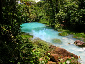
It's located 6 km northeast of Cañas. It is one of the newest parks and part of the Conservation Arenal Area (ACA). Rio Celeste is located 1, 5 km from the Tenorio Area; it is known for its transparent and blue waters. Beautiful cascades with clean white water can also be admired on the way to the volcano.
Fumaroles, hot springs and a 2 day cavalcade to the crater, are some of the main attractions of this imposing active volcano.
Miravalles Volcano
Miravalles volcano is located in the province of Guanacaste. Its boiler formed as a result of several massive eruptions of pyroclastic flow, 0.6 to 1.5 million years ago.
The only eruption documented was relatively small, with a gas explosion that was registered in the southwestern flank in 1946. This Volcano is the highest of the Guanacaste Mountain Range, with an altitude of 2028m.
Bagaces
Bagaces' is an important canton of Guanacaste with incredible history. It was originated after the massive destruction of the city of Esparza, due to pirates incursions in 1687.
Today, Bagaces is a traditional town and is the administrator of many reserves and protected areas in the region.
Palo Verde National Park
Palo Verde National Park is a protected natural space in Costa Rica, declared a national park on June 13th, 1980. It is located in the province of Guanacaste and has 19.000 hectares of extension.
It has low and lacustrine areas that include limestone hills with a low altitude. In 1991, Palo Verde was included in the Ramsar List, which denote the volcano's international importance.
The major rivers drain in this region, creating a mangrove swamp, marshes and evergreen swamps. It has permanent lagoons that allows wildlife's development, including birds, mammals and reptiles. The dry season is the best time to visit the park - December to March.
Lomas de Barbudal Biological Reserve
Lomas de Barbudal has 2646 hectares and it is partly united to Palo Verde. It is known for its protected flora and fauna. There are more than 200 birds’ species, 250 different bees’ species, big crocodiles and many butterflies. It also protects an important tree called the big bang reproducer. This tree is filled with yellow leafs during the dry season.
This reserve has a tropical dry climate.
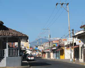
Liberia
 Liberia is Guanacaste's capital city. It arose during second half of the 18th century, under the name of Guanacaste town, as a result of the establishment of an aid parish in this location.
Liberia is approximately 4 hours away from the capital city, San José. It is usually called the “White City” because its streets used to made of “gravel”, a dusty material of white color.
Its climate is hot, dry and humid from November to May and during September and October it gets very rainy. Its average annual temperature is 27ºC.
Liberia has the second international airport of the country, which increases tourism in a great amount. The Daniel Oduber International Airport opens its doors to flights from Spain, London, United States and, of course, for domestic flights as well. Many people still live by the old Sabanero culture - working on land, wearing jeans, a hat and a machete (long knife used to cut grass and hard stuff).
Today, Liberia has grown dramatically when it comes to commerce, education and tourism. It is considered to be the 'second capital' of Costa Rica.
Rincon de la Vieja National Park
This national park has 14.161 hectares and an altitude of 1895m. Rincon de la Vieja Volcano has multiple fumaroles and warm hot springs, including therapeutic springs. This park was created in 1973 to protect 32 rivers. It has had volcanic activity since 1960. Today, the volcano is calmly active but it is not dangerous. This park is home to the national flower, the Guaria Morada. (cattleya skinneri).
Due to the great amount of visitors in the area, there are lots of lodges outside the park, that provide tours and transportation to different destinations in the region.
Junquillal National Bay and Wild Life Refuge
This is 505 hectares of wildlife refuge abd is part of Guanacaste's Conservation Area (ACA). Junquillal is peaceful beach were you can swim, snorkel or get around by boat.
Many species of marine birds, mangroves, pelicans and turtles are found in the area. The Orosi Volcano can be easily spotted from here.
Guanacaste National Park
This park is also part of Guanacaste's Conservation Area (ACA) and has 34.651 hectares of natural beauty. It was created on July 25th, 1989.
From this place you can climb towards two volcanoes, Orosi and Cacao. This park also provides refuge for people who are moving inside this coast and highlands.
Maritza, Cacao and Pitilla Biological Stations
Maritza, Cacao and Pitilla are 3 biological stations bordering Guanacaste's National Park, and are perfect for enjoying and studying Costa Rica's wildlife.
Maritza station: It's the newest station and has a modern laboratory. Hundreds of petroglyphs (images created by removing part of a rock surfaces by incising, pecking, carving, and abrading) have been found from volcanic rocks. The petroglyphs were created by the Chorotega culture.
Cacao station: It's on the top of the Cacao Volcano and has an altitude of 1060m. The Cacao station has irregular trails to walk all over the reserve, connecting with the Maritza station trails.
It is located in the southern part of Guanacaste’s park.
Pitilla station: It is situated in the southeastern side of the Orosi Volcano. Its surrounding forests are humid and cold.
La Cruz
La Cruz is the tenth canton of the Guanacaste province. It covers an area of 1,383.90 km² and has a population of 18,004.
Its capital city is also called La Cruz.
La Cruz surrounds the Pacific coastline with Nicaragua, borders with Bahía Nancite to the south, including the Santa Elena peninsula.
La Cruz has important settlements of Costa Rica's ancient architecture.
Salinas Bay
It is a beautiful place in Costa Rica. It is perfect for windsurfing and kite boarding.
Inside Salinas Bay there is an important island named Bolaños Island. It protects a large amount of seabirds.
Tilaran
Tilaran is a canton located in the mountainous zone of the Guanacaste province, specifically in the Mining Mountain range. It has seven districts: Central, Libano, Santa Rosa, Tronadora, Arenal, Quebrada Grande, and Tierra Morena.
From the city of Tilaran it is possible to discern Miravalles and Tenorio volcanoes and from a few kilometers to the east, the Arenal Volcano could also be seen.
Tilaran, from the indigenous word Tilawa, means “place with winds and rain”. Indeed, Tilaran's climate is fresher than the rest of the Guanacaste province.
Upala
It's located 40 km northwest of Guatuso and 10 km south of Nicaragua’s border. From Upala’s road, you can get to Tenorio and Miravalles volcanoes. Upala’s only town is named, Bijagua. This town is famous for its cheese making.
(506) 2257-4171
Toll Free: 1-877-281-8515
Costa Rica: (506) 2233-5151
Fax: (506) 2233-5284
E-mail: [email protected]
Costa Rica Hotels | Costa Rica Vacation Packages | Costa Rica Tours | Car Rental
Terms & Conditions | Privacy Terms | Contact Us | About Us | Comments & Reviews
The Costa Rica vacations planning site with information about accommodations, tours, transportation, maps of Costa Rica, main cities and travel tips.