-
Hotels
-
By Location
- - Arenal Volcano (La Fortuna)
- - Monteverde
- - Papagayo Gulf
- - Flamingo / Tamarindo
- - Guanacaste, Liberia
- - San Jose City
- - Near International Airport
- - Cahuita & Puerto Viejo
- - Tortuguero
- - Manuel Antonio
- - Jaco Beach
- Other Locations...
Northern RegionNorth Pacific RegionCentral ValleyCaribbean CoastCentral Pacific - Category
- Budget
- Main Cities
-
By Location
- Vacations and Activities
- Where to Go
- Transportation
- Costa Rica Info
-
Maps


Central Valley
Costa Rica Regions / Central Pacific / Caribbean Coast / North Pacific / Northern / South Pacific |
The Central Valley covers the territory from San Ramon of Alajuela (in the west) to Paraiso of Cartago (in the east). To the north, it limits with the Heredia Mountains, the Barva and the Irazu Volcanoes. To the south, it limits with the Talamanca mountain range and on the southwest with the Tarcoles River Valley. It is divided in two sections, the Western Valley and the Valley of El Guarco, separated by the Ochomogo hill.
The Central Valley is the union of Costa Rica’s main cities, San Jose, Heredia, Alajuela and Cartago. It also covers cities or towns with smaller populations like Palmares and Naranjo. More than half of the population of the country is located in the Central Valley; it is also the center of all economic activities, main institutions and the Government.
In average, the Central Valley oscillates between 800msnm (meters over the sea level), in Alajuela and La Garita, and 1.500msnm in San Jose de la Montaña and Tarbaca. It presents temperatures between 12°C and 35°C, depending on the time of the year and the altitude. The capital, San José, presents a temperature average of 20°C.
Its geography tends to have smooth hills and elevations, which increase towards the mountains that define the valley. It does not present extreme variations or geographic features in huge magnitude. It is crossed by different fluvial channels, and it’s in the Central Valley where rivers originate.
In most parts of the country (except for the Caribbean), there are 2 defined stations:
- The dry station called “summer”- characterized by the prevalence of trade winds, clear skies and low temperatures. It goes from November to March.
- The humid station or winter – presents a high level of precipitation that generally appears in the afternoon, mainly in May and October. The atmospheric humidity increases with the temperature. This season goes from April to October/November.
Economic Activities.
They vary depending on culture potatoes to chayote (vegetable pear) in Cartago, to the microprocessors production in the Intel International Company in Heredia. A huge development in commerce areas and in services (banks, hospitals, universities, etc.) has helped the different social classes in the country. In the Central Valley also the main international airport is located. The Central Valley maintains an important relation with different parts of the country. All parts of the country are join by the Inter American Highway.
The only service that the Central Valley doesn’t offers is a port.
Alajuela and the North of the Valley.
During the pre-Columbian era, Alajuela and the north part of the valley were inhabited. On the south, lived the native “huetares” and in the north part the indigenous group ‘guatusos’,’tices’ and ‘catapas’.
I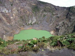 n 1574, the indigenous settlement of Santa Catherine was created, known today as the San Mateo district. In 1777, many families living in great poverty, would have to travel al the way to Villa Vieja, Heredia to attend the church. The long distances and the misery would often make them miss the ceremony. Parish priest Manuel Lopez, worried about the situation, requested a permission to raise a church in the neighborhood. The bishop Esteban Tristán visited the locality and approved the request. On October 12, 1782, the small church was constructed in the town of La Lajuela.
By initiative of the Deputy of Costa Rica Florencio del Castillo Villagra, the Spanish Court granted the title of “villa” (pretentious and luxurious residence with extensive grounds) to Alajuela in 1813. The following year the law was annulled by King Fernando VII, but in 1820, the Court granted the ‘villa’ title to the town once more, and was conserved until 1824, year in which the Constituent Congress of Costa Rica decided to give the name of city instead of villa.
Alajuela has a great flora and fauna diversity protected in two national parks, the Poás Volcano and the Juan Castro Blanco. Alajuela has also a national reserve for wild fauna (in Caño Negro), five protected zones and several forest reserves.
As a tourist attraction, the Museum Juan Santamaria exhibits locally produced crafts. Inside the museum, a room revives the history of the battle of Santa Rosa (when Costa Rican troops beat the filibusters commanded by William Walker, in 1856).
The colorful cities of San Ramon, Zarcero and Sarchí are another pride of the Alajuela province. In these towns you can acquire Costa Rican hand-made crafts and admire the wood works as well.
Sarchí is the crib of Costa Rica’s crafts, where the wood retrieves up life and offers the tourists a great variety of “souvenirs” elaborated with precious local wood. It is the place where folklore takes place and colorful wooden cars became a national symbol.
There two active volcanoes in the zone: the Arenal Volcano, on the corner of San Carlos, and Poás Volcano, whose crater is 1km in diameter and 314 meters deep.
The Poás is one of the very few active and accessible volcanoes in the world; it is 2,704 meters above sea level, in the Central Volcanic Mountain range, and is located 37 kilometer north of Alajuela. It is possible to observe, the bottom of the crater, active fumaroles and small eruptions.
This park protects the rivers that make up the North hydrographic river basins. Around the volcano, in the park area, a vast wooded forest is populated with a great number of birds and small mammals. The place is 35 kilometers from San Jose, and has a sanitary service, information center, signalized footpath, picnic place and a history and exhibition room.
The province of Alajuela is divided in 15 cantons and in 107 districts. The cantons and their respective main cities are:
1. Alajuela, Alajuela
2. San Ramón, San Ramón
3. Grecia, Grecia
4. San Mateo, San Mateo
5. Atenas, Atenas
6. Naranjo, Naranjo
7. Palmares, Palmares
8. Poás, San Pedro
9. Orotina, Orotina
10. San Carlos, Ciudad Quesada
11. Alfaro Ruiz, Zarcero
12. Valverde Vega, Sarchí
13. Upala, Upala
14. Los Chiles, Los Chiles
15. Guatuso, San Rafael
Orientation
Alajuela is very similar to San Jose in different aspects. It’s a busy city with easy access to all services. Alajuela is home to Costa Rica’s Juan Santamaría International Airport, making it a convenient spot for tourists as well.
Alajuela has great historical importance thanks to national hero Juan Santamaria, who was born in this beautiful province. Santamaría burned the military headquarters in Rivas Nicaragua and fought against the American filibusters commanded by William Walker. Costa Rica’s hero died in combat but he assured his loved country independence and peace.
Atenas and La Garita
It is a town located in the west side of the province of Alajuela. This village is historically known as “carts way”, due to being the place where carts were loaded with beans and then driven to Puntarenas. Atenas is also well known for having the best weather in the country.
La Garita and is located 11 km from Alajuela downtown and is known to be a ‘corn town’. Restaurants in the area specialize in delicious corn food. The restaurants in this zone are specially for making corn food.
Sarchí: Located in the Northwest side of Alajuela, Sarchí is a popular small town characterized by two things mainly: its wooden carts, that have become a national symbol, and its fresh and flowering trees. Excellent coffee quality can also be found in the area.
Grecia: This is traditional small town known for having perhaps the prettiest church in the country. This famous church was created in Belgium and shipped to Costa Rica in 1897. It’s a very clean and cozy town with a wide variety of insects and beautiful landscapes.
Palmares: Palmares is claimed for its annual parties. This is a 10-day party in the middle of January with carnival, rides, fireworks, discos, bars, food and horse parades. It is totally covered by the television channels, since over 10.000 people come to town.
If you are in Costa Rica during January you will see the posters advertising events and providing more detailed information.
San Ramon: it is the second canton of the province of Alajuela and has an area of 1,155 k m, which represents 2% of the Costa Rican territory. The city of San Ramon is an important commercial center and is the most important city, outside the Great Metropolitan Area. It is home to Universidad de Costa Rica’s headquarters and numerous public organizations. In addition, it’s a natural paradise with many tourist attractions.
Naranjo: it’s located five kilometers away from Sarchí. It’s an important agricultural place, as well as a traditional and cultural town. The Naranjo main road goes all the way up to Ciudad Quesada and Zarcero.
Zarcero: it’s located to the north of Naranjo, at the end of the Central Mountain Range. The high mountains and the fresh air create a cooler climate, making it quite unique in Costa Rica. Zarcero’s park is the main attraction for visitor, as it has lots of pine trees beautifully shaped.
North of San Jose
Heredia
Heredia province is located in the North part of the country, 12 km north of San José. It limits with Nicaragua (to the north), in with the province of Limon (to the east), with the province of San Jose (to the South) and with the province of Alajuela (to the west). Heredia is the smallest province of Costa Rica, but it is extremely important for its coffee plantations.
It has an altitude of 1150 meters above sea level and maintains an average temperature of 23º C. The capital of the province is the city of Heredia, well-known as the “city of the flowers”. It is the venue of the National University, one of most important public universities of Costa Rica.
This province offers the ecological wonders of the Central Mountain range. The Barva Volcano has 2,906 meters above sea level.
As well, the rainy Braulio Carrillo forest is a popular tourist attraction, as well as its rural t owns of San Isidro and San Rafael, which exhibit beautiful gothic revival churches and scenic places with great beauty.
It is divided in 10 cantons:
1. Heredia
2. Barva
3. Santo Domingo
4. Santa Barbara
5. San Rafael
6. San Isidro
7. Belen (San Antonio)
8. Flores (San Joaquin)
9. San Pablo
10. Sarapiqui (San Pablo)
Barva: It is located just 3 km north of Heredia. It was founded in 1561 and is now considered to be a national monument. Barva is a small town surrounded by mountains and has a colonial environment with historical buildings and the beautiful San Batolomeo church.
Today, Barva has beautiful hotels for its many visitors and many attractions including the Basilica of Barva Church constructed in 1767, The Museum of the Popular Culture, one and a half km southwest from Barva downtown and the Coffee Museum, opened in 1834.
Barva Volcano hills
• San Jose de la Montaña: located in the north side of Barva, it’s known for its beautiful church and its many hotels inside the pine forest.
• Monte de la Cruz: located two km north of Heredia, it’s known for its old gothic church and its many mansions all along the roadside.
Braulio Carillo National Park
It is located in the Central Volcanic Mountain range, to the north. The Barva Volcano, Cacho Negro and the Bajo de la Hondura make up this naturally amazing park.
Braulio Carrillo constitutes the second Biosphere Reserve of Costa Rica and its forest provides an important amount of oxygen. It also has a wide variety of flora and fauna, including orquids, ferns and birds.
East of San Jose
Cartago
Cartago city is located in the central region of Costa Rica. It was founded in 1563 by the Spanish conqueror Juan Vazquez de Coronado and was Costa Rica’s capital city for about 300 years.
Cartago was the first permanent Spanish establishment in Costa Rica and was home to Spanish governors until the country’s independence in 1821. According to the Concord Pact signed in , the capital city would rotate between Cartago, San José and Alajuela. However, as a result of a civil war, the capital city was permanently moved to San José.
Cartago was the seat of the Central American Justice Court and was the first Central American city in establishing an International Rights Court, along with the Human Rights Court.
Today, Cartago is a modern but historical city with 127.000 inhabitants and is famous for its majestic church ‘La Basílica de los Angeles’.
Basilica de los Angeles
The Basilica of Los Angeles is a catholic temple in the city of Cartago, constructed in 1639. an It’s an amazing Byzantine style church where, according to Costa Rica’s religious, an image of the Virgin Mary miraculously appeared to a young girl in 1635.
Romeria
Each year on August the 2nd, thousands of people, not only from Costa Rica but from all over the world, still peregrinate to honor the virgin of ‘Los Angeles’ and to render homage for favors conceded. The peregrination is better known as the ‘Romería’.
National Park Irazu Volcano
The Irazú is an active volcano located in the Central Volcanic Mountain Range inside the national park, 30 km west of Cartago downtown. It was named after the indigenous community ‘Istarú’, whi lived on the side of the mountain.
Irazú Volcano has 3432 meters of altitude and it’s cone shaped with several craters, one of which contains a green crater lake of variable depth. This beautiful national park can be easily visited from the capital city of San José.
On a sunny day, it’s possible to see both the Atlantic and Pacific Oceans from the top of the volcano. The National Park was protects 2309 hectares around the volcano.
Orosi
Beautiful Orosi Valley is only an hour drive from the capital city of San José. The town of Orosi is home to Costa Rica’s oldest church, which is still in use by faithful locals.
On a clear day, the splendorous Orosi Valley, along with its flowing river, can be visible from the top of the Irazú Volcano.
The Orosi River flows out of the Talamanca mountains and Tapantí National Park, through the valley and into a lake which was formed by the construction of the Cachi Dam.
One interesting attraction between the village and the dam is La Casa del Soñador (The House of the Dreamer), a small house made of coffee trunks, each one sculpted into unique forms and figures.
The road around the south side of this artificial lake will take you through the village of Cachí and to the dam.
Continuing across the dam, you will get to the village of Ujarrás, known for its ruins, dedication to coffee production and beautiful gardens.
National Tapanti Death Hill Park
It protects the Northern slopes of the Talamanca Mountain Range and is one of the wettest places in the country. In the year 2000, this park expanded 585 hectares and now it is part of the Death Hill.
Turrialba
Turrialba is 650 m above sea level. Turrialba River follows the Reventazon River and passes through the Central Mountain Range. In 1991 a tremor stroked the country but Turrialba, with a population of 70,000 inhabitants didn’t suffer.
Turrialba has the best access for white water springs.
Guayabo Arquaeological National Monument
Guayabo is 19 km northeast of Turrialba city. It’s a contrast between the Mayan and the Aztec cultures. Its aqueduct system has served for more than 20.000 people in the area.
Turrialba Volcano National Park
Turrialba volcano is a large, densely forested, active volcano. Described by many as Irazú’s twin volcano, Turrialba has unique natural attractions such as hiking along the trails, which allows visitors to see the several lava flows, evidencing the once flowing rivers of hot magma.
Costa Rica Regions / Central Pacific / Caribbean Coast / North Pacific / Northern / South Pacific
(506) 2257-4171
Toll Free: 1-877-281-8515
Costa Rica: (506) 2233-5151
Fax: (506) 2233-5284
E-mail: [email protected]
Costa Rica Hotels | Costa Rica Vacation Packages | Costa Rica Tours | Car Rental
Terms & Conditions | Privacy Terms | Contact Us | About Us | Comments & Reviews
The Costa Rica vacations planning site with information about accommodations, tours, transportation, maps of Costa Rica, main cities and travel tips.