Caribbean Coast
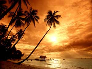 The Caribbean Sea is a tropical open sea of the Atlantic Ocean. It is located in the east of Central America and in the north of South America; it covers all the surface of the Caribbean Plate. It is also called the Antilles Sea because it is situated at the south and the west of the Antillean arc.
The first inhabitants of the Antilles islands were the taínos, sedentary tribe with religious beliefs of polytheist character and with good agriculturists, fishermen and potters. Its language is derived from the Arawak; this family came from South America migrating about 3000 years ago approximately. At this moment of the discovery, the Caribbean’s, who stood out by their abilities as navigators and soldiers and occupied the region predominantly. They originate in the Orinoco River and start conquering the taínos territories.
In 1502, Christopher Columbus was the first person to put a foot in Costa Rica’s Caribbean.
He visits Playa Uvita for the first time. This was his fourth voyage. Twenty two years later Hernan Cortes after visiting Costa Rica mapped the entire Caribbean coast. The Caribbean Coast in Costa Rica, extends from Nicaragua to Panama, it covers 200 km.
It comes from north to south. It covers the Limon providence; also it divides this providence in two districts, North of Puerto Limon and South of Puerto Limon.
North Limon comes from Tortuguero Canals to Nicaragua’s border. The South of Limon is the Talamanca coast.
Limon history
Limon is a province of Costa Rica; it is in the Easter part of the country. It limits the northeast with the Caribbean Sea, the west with Heredia, Cartago and San Jose, in the southwest with Puntarenas and in the Southeast with Panama.
 Limon is to pearl it of the Costa Rican Caribbean. It is known for its great cultural diversity. With a predominantly black population and important characteristics of the Costa Rican indigenous culture, afro Caribbean, white and Chinese, each group contributes to the zone and gives them their its own style. It is the zone where more cultures converge in Costa Rican territory.
It has a hot typical climate of the coasts and very humid, its annual temperature average is of 25.5º C. The historical marks of temperature in Limon are of 15C and 35C. This located providence is about 209 km of San Jose. In the south of the province, in the Mountain range of Talamanca are the highest summits of the country, between them, the Chirripo hill is culminating point of Costa Rican geography. It is to 3,819 ms of altitude above sea level and whose nocturnal temperature sometimes is less than zero degrees in the dry season. In 1973 a brief snow fall was reported in its peak.
It has located in its territory the petroleum refiner (RECOPE) and several state institutions like JAPDEVA. It is a zone little industrialized zone which is dedicated to a great extent to agriculture. It has the biggest and the greater banana’s production of the country, Costa Rica is the second world-wide exporter of this fruit. It suffered a devastating earthquake in 1991. Its port is the most important of Costa Rica and one of the greater centers of transit containers of Latin America.
Limon makes its available 336 km white sands, beaches and palms exuberants national parks. This is the answer of the tropical humid forests and reefs of chorale, as well as the hundreds of species of flora and fauna on the way to extinction. This province is located in the whole Caribbean coast. Limon is divided in 6 cantons and 27 districts.
ATLANTIC HILL
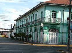
Puerto Limon
It has an extension of 1.765,79 km² and a population of 105.000 habitants. It is divided in four districts, Limon, Valle de la Estrella, Rio Blanco and Matama.The decrees of 1992 defined the four districts and create the central canton. This new division facilitates in addition the electoral organization.The city of Lemon is the head of all cantons in Limon. It is the port of the greater importance in the country and is located in the Caribbean coast of Costa Rica.
Limon is one of the shipping centers more important containers of Latin America in the Caribbean this is because of the harbor zone is almost in a 90% of the exports and imports of Costa Rica.
In its periphery we also found the Costa Rican Petroleum Refinery, RECOPE and several factories of paper especially in cardboard destined and in manufacturing of boxes for packing and exporting the banana tree. Limon is the second world wide exporter of the banana product.
Independent institutions like JAPDEVA, is the one uncharged of the development and the harbor administration of the slope of the Caribbean in Costa Rica, with the central seat in the city of Limon.The carnivals of Limon’s city emphasize the famous popular celebration of the province, which is a celebration in the month of October, supposedly when the Spaniards arrive to Costa Rican land.
Guápiles
It was declared a city in 1966. It principal town is known as Pococi. It has an extension of 2.403,49 km². It is the second important canton in Limon.It has 115.000 inhabitants. Its territory is divided in 6 cantons, Guápiles, Jimenez, Rita, Roxana, Cariari and Colorado.
The city of Guápiles is an important commercial and banking center. It has numerous schools and important universities. It also has institutions of superior public and private education. It is the heart of a prosperous agricultural and cattle region that organizes the ExpoPococí. They have fairs annually, one of most important of the country, in the area of the cattle ranch. To the north part of this canton is the National Park of Tortuguero, one of the more visited sites in Costa Rica. Also it is famous world-wide by its scenic beauty, its biodiversity and by the presence of the marine turtles that arrive every year for the egg- laying. This canton is communicated with Puerto Limon, capital of the province, and with the rest of the country through a modern highway.
Tortuguero National Park
The Tortuguero National park located in this zone, it contains the greatest sample of humid forest tropical. Here you are able to cross the river channels, to observe the flora and the fauna, to appreciate the egg-laying of the marine turtles and to have the opportunity to observe more than 300 species of birds. In this zone scientific researches are carried out important studies and it has become a special point for the scientific and ecological tourism.
Siquirres
Siquirres is the third canton of the province of Limon in Costa Rica. It was created by the law n° 11 the 19th of September 1911. It is the center of the province of Limon, it has low lands, this is the reason it has low temperatures around 29°C. In the last years the principal activity was the agriculture. Its mainly activity is the production of the banana and the pineapple. It is communicate officially by a highway with the rest of the province and the country.In the last years the tourism has acquired importance, most of this tourist visit the rivers Pacuare and Reventazon.
It has a territorial extension of 860.19 km ² and a population of 59,000 inhabitants.
It has six districts, Siquirres Pacuarito, Florida, Germania, Cairo and the Alegría town.
Talamanca
Talamanca is the most extensive of the six cantons of the province of Limon in Costa Rica. It displays a greater, a highest and an extensive biodiversity since its climate goes from the humid tropic to the cold deserts that origin in the glacier of the Mountain range of Talamanca. Mountains arrive at the 3,819 meters on the level of the sea, like the Chirripó Hill, culminating point of Costa Rican geography.
Its beaches are counted as the most beautiful of Costa Rica, among them: The National Cahuita Park, with a unique barrier of chorales in its sort, the Vargas Port, Puerto Viejo beach, Gandoca- Manzanillo beach, Black beach and many more.
The reserve named Hitoy-Cerere is one of the most visited of the canton. The composition of its population varies as the nature. In Talamanca you can appreciate different ethnic groups, like the Talamanca’s original Cabecar and Bribri groups, another important group are the people that descend from Africans , amongst others, a big group of Chinese people also live here. In addition to the Spanish, each community conserves its respective languages.
The canton also counts with a costumer post in Sixaola on the border with Panama. Sixaola is an important producer of banana tree for the export.It has a territorial extension of 2.809, 93 km ² and a population of 30,000 inhabitants. It is divided in 4 districts, Bratsi, Sixaola, Cahuita and Puerto Viejo.
Matina
Matina’s canton is fifth of the province of Limon. It was created by the law 4344 in 1969. Although the head of this canton is known as Batan, it has an important population and many commercial centers.The main economical entrance of Matina is the agricultural contribution, specially the banana production although in a less contribution the cattle ranch also helps and gives work. Matina is divided in 3 districts, Matina, Batan and Carrandi. The climate is rainy, typical of the Atlantic slope. The months of less rain are October, March and April. The temperatures oscillate between 24 and the 30 ºC.
A branch joins Matina with the center with the hard road surface of Limon. The distance between Matina and San Jose is of 168 kilometers.
In general, good routes do not exist, except in the region of Batan were some ways lead to different property.
Guácimo
Guácimo is the sixth and more recent canton of Limon providence. It has 5 districts, Guácimo, Mercedes, Pocora, Rio Jimenez and Duacari.
In the district of Mercedes, a very important university is situated. It is known as the EARTH, Humid Tropical School, internationally recognized level by a high quality level in its academic program of investigation in a the area of tropical agriculture. Guácimo is located in the plains of the Caribbean, and counts with great areas cultivated with banana tree, yucca, maize and others. Also many lands are dedicated to the cattle ranch. In the past, the zone it was habited by indigenous groups and at the moment archaeological excavations in several establishments have began. In the low zones there are great amount of sewers and lagoons.
The pluvial precipitation has an average of 2.100 mm in a year. The months of fewer rains are September, October, March and April. The temperature average oscillates between 24 and 33 ºC. A great amount of rivers give abundant fishing and have extensive plantations of banana tree. The National Museum of Costa Rica has made excavations which have revealed roads and pavements, which demonstrate the importance of the indigenous establishments. Commonly well-known as the Old -Line, this route is between Guápiles, Guácimo and Siquirres.
Around Puerto Limon
-
Uvita Island : It is 1 km from Limon coast. It is very popular for its beach to surf, to thrill and to punish you with lots of adrenaline.
It could have waves of 3m in nice days. If you want to get here by road you will last like 6 hours from San Jose and if you want you can take a boat from Limon port and you will last just 20 minutes. Isla Uvita is a clean and a protected beach. -
Bonita Beach : The sandy seashore and a delicious ocean for swimming characterized this beach. Surfers like this beach because of its reef break which gives power to the waves. This beach is before you get to Puerto Limon downtown. In the north it has a bay called Portete.
-
Moin : In this town you can take a boat and visit many places, Parismina, Tortuguero or even Barra Del Colorado. Since 1974 this river canal system are very famous and safe. Boats don’t have to get to the sea, they only transport by these systems.
Northern Caribbean
Lots of rivers and canal characterized this zone. A climate between humid and tropical makes people feel in a fresh beach. Lots of forests and amazing nature surrounds this protected area. Flora and fauna is founded in every corner of Caribbean.
Parismina
This city is located in the south of the Tortuguero National Park. Parismina is known especially for its river. In Parismina two kinds of tourists visit this place, turtle and tarpon lovers. Parismina is surrounded by river. Some places like Parismina Scroll are accessible only in boat this is the reason that it conserves the named of Island, because it access is very difficult. The principal sport in this town is the sport fishing. The best season to visit this place is from January to May. Tourists also come and visit the scarce sea turtles.
Tortuguero National Park
This park is located in the north of the town in Tortuguero and in the south of Parismina. Its climate is humid and dry. Its annual rain arrives at 6000mm in the North of the park. It is one of the rainiest areas in the country. It doesn’t exist the dry time, but it rains fewer in February, March and October.The famous canals are an introductory part of Tortuguero.
This place was created with natural lagoons and rivers. In addition the banana plantations and the wild jungle will make you enjoy this place.
The park counts with 31,187 terrestrial are hectares and 52,000 marine hectares. Its black sand gave birth to turtles, they live and procreate here. Tortuguero has lots of different animals too, amounts of monkeys, frogs, iguanas, fish, crocodiles, manatees, pumas and many animal species more, that you can find in this jugles sides.
You can also try many activities like, hiking, boating, turtle, bird and wild life watching and having delicious marine food.
Getting there
-
Air: In Tortuguero a small airfield 4 km away from Tortuguero downtown will help you get there. Nature Air and Sansa have daily flight to make you get there.
-
Boat: There are two ways of getting a boat, from Cariari and from Moin ports.
Barra Del Colorado
Including the border of Nicaragua it has approximately 90,400 hectares. It is the great refuge of flora and fauna. The refuge contains 50 km of the area in the coast; in addition lots of kilometers are in distributed in the channels, lagoons and rivers. Amounts of rain fall in a year. The rivers San Juan, Colorado and Chirripo make their way towards the Caribbean Sea. Barra Del Colorado is much more expensive and difficult to visit that Tortuguero. Mammals, caimans, crocodiles and different species of fishes surround this forest. Lots of impressive colors of birds describe this zone, two species of wild cats, monkeys and tapirs describe this zone too. Activities like fishing, canoeing and kayaking can make you feel the real adventure.
Southern Caribbean
In this part of the country, the heart and the soul of all the Afro Caribbean culture is everywhere. The simple answer to this is because with the United Fruit Company all Jamaicans came to work in the Atlantic part of our country. Now days this part of the country is likely to an airport, international cultures live and procreate here. Italians, French’s, Spanish, Jamaicans, Argentineans live and surround this paradise.
The international commerce and sales have benefited this providence and increase their quality. The southern Caribbean is a mixture of a piece of each country.
Biological Reserve Hitoy-Cerere
The reserve of Hitoy-Cerere is one of the craggiest and rarely visited. It is 60 km away from Limon and in the edge of Talamancas coast. This forest has between 4000mm and 6000mm of rain annually. The named of this reserve is given because of two rivers, the Hitoy (means covered rocks) and the Cerere (means clear water). These rivers define the landscape. Wildlife is plentiful, lots of mammals and reptiles appear everywhere. It is a humid forest.
Cahuita
It has precious beach. It is the neighborhood of Puerto Viejo. You can miss visiting this beach. Cahuita is the most relaxing city of the whole Caribbean. Most of its business is still owned by locally people. It has black sand that makes this beach curious. It has a big National Park which is five minutes from down town. Cahuita is a small town, which has always been a protected zone, with hardly recycle campaigns. It is also considered one of the most beautiful places in Costa Rica. Its weather varies; it can be very hot sometimes and very cold at night.
It is also characterized for it humid tropical climate. Like in all the towns of our country, dangers and annoyances exist. Woman sometimes come to this town just for a quick fling, so be careful, they could be wrong about you. The Caribbean beach is an international place for all people so this means that venereal disease may be everywhere.
Cahuita National Park
It has 1067 hectares. It is very visited because it is very near of Cahuita downtown, this means it is near and has an easy access.You will find white sand, coral reefs and coastal forest with an amazing wild life. It was declared a National Park in 1978. This park is very humid surrounded with coconut plants. You can also see many swamps. In this national territory you can find all kinds of mammals and reptiles.
It is recommended to realize activities like, hiking, swimming and snorkeling.
Puerto Viejo de Talamanca
Do not get confused with Puerto Viejo of Sarapiqui. Puerto Viejo is a mixture between beautiful beaches, delicious food and nice night life.
It is totally international beach. The Afro-Caribbean and the reggae culture is really strong in this place. You will always look to French or Italian people. International fusion cuisine is the principal description of Puerto Viejo. Music lovers will enjoy dancing salsa, hip hop, rock and all rhythms. Puerto Viejo has a huge beach for surfing with many opened- air bars. Puerto Viejo beach comes from Playa Negra, Salsa Brava, and Cockles beach to Uvita seashore. Look always for a safety hotel.If you prefer to enjoy your time on watching animals, you can visit the Wild Life National Refuge.
Getting Here
You can get here by different ways:
-
Car : These roads are not in a very good way, rent a 4 WD car and it will be easier.
-
Bus : Coope Mepe; public transport located in Barrio Tournon in San Jose has 4 daily buses that drive into this zone.
Also you can call Gray line buses and they will pick you up in the hotel. -
Air : there is an International Airport in Limon. After arriving Limon you will have to drive to get there.
Manzanillo
Manzanillo is 13 km from Puerto Viejo, it is 15 minutes long. Lots of cycling is made because this is a straight road and clearly paved.
In 1985 they named this zone National Refuge of Wild life which is now helping with the development of the zone. It has a few hostels and grocery stores all over the place. This is a calmed town. All people live in a very slow daily routine. Restaurants with seafood are the preferred food.
You can realize many activities like, hiking, snorkeling, diving, kayaking, sport fishing and also dolphin observations.Manzanillo National Wild Life Refuge It is also known as Regama, for a shorter name. It is located in the Talamanca canton It protects a 70 % of the Caribbean coast. It has 5013 hectares of land and 4436 hectares of sea. It was the first place of cocoa growing region. It protects the wild fauna, in special those species on the way to extinction or with reduced population. It has a lagoon, which classified this Atlantic region as a humid forest. The primary forest that is in this area is of unique value, it has a small relative surface covered with life and low lands.
It has a great diversity of terrestrial habitats with parts of primary forests and numerous marine habitats and chorale reefs, they conserve very well because of the conditions of the Atlantic coast climate.
Bribri
The Bribri constitutes one of the more numerous ethnic groups of Costa Rica. Although the distribution of the Costa Rican native cultures before the conquest is not very known actually, it is certainty known that the Bribri’s and the Cabécares groups live in the Talamanca mountain range. The social system was based on the tribal chief’s politics. The Bribri and the Cabecar population reached about twenty-seven thousand natives in the arrival of the European conquerors.
In the present time, about 10000 individuals Bribri’s live in the South region of Costa Rica. They mainly live in the indigenous reserves of Salitre and Cabagra, in the Buenos Arias canton located in the Province of Puntarenas and in the Talamanca reserve with the same name.
Sixaola
It is a town and it is the border river between Costa Rica and Panama. According with the Echandi- Fernandez trade in 1941, both countries have right of the free navigation in the Sixaola river and in the bordering line that runs in the center of the channel. It is formed by the flowing together of several rivers, among them, the Tarire River, the Yorkin River and many others. Its name is from indigenous origin and in some sources appeared mentioned like Sigsaula or Sixaula. Foreign tourist travel by the street named Paso Canoas or the Carretera Internacional. Remember Sixaola is a border coast town. In Sixaola is the Mercado Internacional de Sixaola, where you can find, food, stores and cheap stuff. Public and private buses can drive you here.
Costa Rica: (506) 2233-5151
Fax: (506) 2233-5284
Fuera del horario regular y fines de semana: (506) 2257-4171
E-mail: [email protected]
Términos y Condiciones | Términos de Privacidad | Contacto | Nuestra compañía
El sitio para planear sus vacaciones en Costa Rica con información sobre alojamiento, tours, traslados, mapas de Costa Rica, principales ciudades y consejos para viajeros.
English Version