Central Valley and Highlands
The Central Valley covers the territory from San Ramon of Alajuela in the west, to Paraiso of Cartago in the east. In the north it limits with 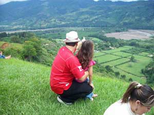 Heredia Mountains, with the Barva and the Irazu Volcano. In the south it limits with Talamanca mountain range and in the southwest with the valley of the Tarcoles River. It is divided in two sections, the Western Valley and the Valley of El Guarco, separated by the Ochomogo hill. The Central Valley is the union of the most important populations of Costa Rica, San Jose, Heredia, Alajuela and Cartago. Also it covers places with smaller population like Palmares and Naranjo. More than half of the population of the country it is located in the Central Valley; it is also the head office of the Government, of the main institutions and of economic activities.
In average, the Central Valley oscillates between 800msnm (meters over the sea level) in Alajuela and La Garita and 1.500msnm in San Jose de la Montaña and Tarbaca. It presents temperatures between 12°C and 35°C, depending on the time of the year and the altitude. The capital, San Jose, presents a temperature average of 20°C.
Its geography tends to have smooth hills and elevations, which increase towards the mountains that define the valley. It does not present extreme variations or geographic features in huge magnitude. It is crossed by different fluvial channels, and is in the Central Valley is where rivers originated.
Almost in all the country (excepting for the Caribbean), it presents 2 defined stations:
- The dry station called “summer” is characterized by the prevalence of trade winds, days without clouds, and low temperatures. It goes from November to March.
- The humid station or winter, presents numerous rains that appear generally in the afternoon, mainly in May and October. The atmospheric humidity increases with the temperature. This season goes from April to October/November
Economic Activities.
They vary depending on culture potatoes to chayote (vegetable pear) in Cartago, to the microprocessors production in the Intel International Company in Heredia. A huge development in commerce areas and in services (banks, hospitals, universities, etc.) has helped the different social classes in the country. In the Central Valley also the main international airport is located. The Central Valley maintains an important relation with different parts of the country. All parts of the country are join by the Inter American Highway.
The only service that the Central Valley doesn’t offers is a port.
Alajuela and the North of the Valley.
During the pre-Columbian era it was inhabited .In the south part the native “huetares” and in the north part the indigenous group “guatusos , tices and catapas”.
On 1574 the indigenous settlement of Santa Catherine was created, which today it is known as San Mateo district. In 1777 many families, who lived in a great poverty had to go for the religious offices to the only church in Heredia called Villa Vieja. The long distances and the misery made them miss the ceremony. The parish priest Manuel Lopez, worried about this situation and request a permission to raise a church in the neighborhood. The bishop Esteban Tristán visited the locality and approved the request with a small praying center. The 12th of October 1782, the small church was created in the town called La Lajuela.
By initiative of the Deputy of Costa Rica Florencio del Castillo Villagra, the Spanish Court granted the title from “villa” (pretentious and luxurious residence with extensive grounds) to Alajuela in 1813. The following year the law was annulled by King Fernando VII. In 1820 the Court again granted that title to the town, which was conserved until 1824, year in which the Constituent Congress of Costa Rica decided to give the name of city not of villa.
The origins of the name Alajuela differ in many meanings. The commonest version dates that from the beginning a small town called Guadalupe was surrounded by two rivers, in which the stones were something well-known like “lajas”, so somebody put this name to the town. The time past and deform the sound which today it is Alajuela
Alajuela has an animal diversity and lots of plants that are protected in two national parks, the Poás Volcano and in the Juan Castro Blanco. Alajuela also has a national reserve for wild fauna (in Caño Negro), five protect zones and several forest reserves.
Like a tourist attraction the Museum Juan Santamaria, exhibits locally produced crafts. Inside the museum a room revives the history of the battle of Santa Rosa. This was when Costa Rican troops beat the filibusters commanded by William Walker, in 1856.
Another important part of Alajuela are the colorful cities of San Ramon, Zarcero and Sarchí. In these towns you can acquire Costa Rican crafts hand-made and admire the wood works of the craftsmen in the famous painted carts.
Sarchí is the head of the Costa Rican crafts, where the wood retrieves up life and offers the tourists a great variety of “souvenirs” elaborated with precious local wood. It is the place where the folklore takes place. The typical carts were created in this place with the correct wood and color which today it is a national symbol.
 There two active volcanoes in this zone: the Arenal Volcano in the corner of San Carlos and Poás Volcano, whose crater is for 1km of diameter and 314 meters of depth.
The Poás is one of few active and accessible volcanoes; it is 2,704 meters on the level of the sea, in the Central Volcanic Mountain range, and is located to 37 kilometer north from Alajuela. It is possible to observe, the bottom of the crater, active fumaroles and small eruptions. This park protects the easts of the rivers that compose the North hydrographic river basins. Around the volcano, in the area of the park, a vast wooded forest is populated with great number of birds and small mammals. The place is 35 kilometers from San Jose, and counts with a sanitary service, information center, signalized footpath, picnic place and a room with history and exhibition. The visit offers a visit throw the splendid route by the humid tropical forest. In this tour you can see numerous species of abundant ferns and trees with a great lushness.
The province of Alajuela are divided in 15 cantons and in 107 districts. The cantons and their respective heads are:
- Alajuela, Alajuela
- San Ramón, San Ramón
- Grecia, Grecia
- San Mateo, San Mateo
- Atenas, Atenas
- Naranjo, Naranjo
- Palmares, Palmares
- Poás, San Pedro
- Orotina, Orotina
- San Carlos, Ciudad Quesada
- Alfaro Ruiz, Zarcero
- Valverde Vega, Sarchí
- Upala, Upala
- Los Chiles, Los Chiles
- Guatuso, San Rafael
Orientation
Alajuela is very similar to San Jose. It has streets and avenues. What ever you need you can find it, hospitals, clinics, banks, tourist information. Alajuela is the nearest town from the airport so many people prefer going to Alajuela and not coming to the capital.
Alajuela also is very near from all Pacific coast beaches. It is one of the hottest part of the country. Alajuela is also known for his hero Juan Santamaria. He burned the military in on Rivas Nicaragua. He fought against the American filibusters commanded by William Walker. At the end he died by he assured the country that the enemies were not coming again. Juan Santamaria was born in Alajuela.
Atenas and La Garita
It is a town located to the west side of the province of Alajuela. This village is historically known by the name of “carts way”. These carts loaded frijoles towards Puntarenas. It has the best and hot climate of the country.
La Garita is a corn town. It is located 11 km from Alajuela. The restaurants in this zone are specially for making corn food. They have the biggest bird collection in Central America.
Sarchí: Located in the Northwest of Alajuela. It has cultivated hills. These near towns are normally known in Costa Rica by the get-aways. This town is very popular and ancient so when anyone comes to visit they feel like in home. Sarchí is characterized by two things. The first thing is that it is the only producer of wooden cart. The wooden cart is the typical symbol that represents the workers. All this wooden carts are constructed thanks to the trees. Sarchí has lots of fresh and flowering trees. This region also has excellent coffee and eccentric attractions. Sarchí is divided by the Trojas River. This means that Sarchí is divided into North and South.
Grecia: This is another west town. It has the prettiest church in all the country. This famous church was created in Belgium and chipped to Costa Rica 1897.People think that in Grecia all the money people live. It is the cleanest place in all Latin America. It also has a variety of insects to display. In the 18th century rock bridge, connecting the hamlet of Rock Bridge and of Salas Corner.
Palmares: Palmares is claimed for its annual parties. This is a 10-day party in the middle of January. Carnival, rides, fireworks, discos, bars, food, horse parades. It is totally covered by the television channels. More than 10.000 people come and visit this town.
If you are in Costa Rica in January you will see the posters advertising all events and detailing events.
San Ramon: it is the second canton of the province of Alajuela. It has a total area of 1,155 k m, which represents 2% of the Costa Rican territory. The city of San Ramon is an important commercial center and is the most important city of the high zone of Costa Rica outside the Great Metropolitan Area. It is the head of the University of Costa Rica which is the regional bench of numerous public organizations. It is in addition the capital to a very great corner with great amount of natural and tourist resources
Naranjo: Five kilometers away from Sarchí. It is a vey important agricultural place.It has the nicest Catholic Church, two towers, white color, and a red roof make this church unique. The north of Naranjo guide Ciudad Quesada road. It also coils with Zarcero.
Zarcero: This is a t the north of Naranjo. It is located at the end of the Central Mountain Range. The Mountains and the fresh air make these zones a cold climate place. Like all this towns Zarcero has something very special, the Central park has lots of tree pines. Zarcero is between San Jose and Ciudad Quesada.
North of San Jose
Heredia
 Heredia, province of Costa Rica. It is located in the North-part of the country. In the north it limits with Nicaragua, in the east with the province of Limon, in the south with the province of San Jose and in the west with the province of Alajuela. Heredia is the smallest province of Costa Rica. It is the coffee heart with famous plantations of this gold grain. It is located 12 km from San Jose. It has an altitude of 1150 meters on the level of the sea. It maintains a temperature average of 23º C. The capital of the province is the city of Heredia, well-known like the “city of the flowers”. It is the venue of the National University, one of most important public universities of Costa Rica.
This province offers the ecological wonders of the Central Mountain range. The Barva Volcano has 2,906 meters on the level of the sea.
Another important attractive is the rainy forest Braulio Carrillo. A colonial tradition is presented in some houses, painted the same way as years before.Their rural towns of San Isidro and San Rafael exhibit beautiful gothic revival churches and scenic places with great beauty.
It is divided in 10 cantons:
- Heredia
- Barva
- Santo Domingo
- Santa Barbara
- San Rafael
- San Isidro
- Belen (San Antonio)
- Flores (San Joaquin)
- San Pablo
- Sarapiqui (San Pablo)
Barva: It is just 3 km north of Heredia. It was found in 1561 and is a national monument. The entire town has old building, in the center the San Bartolommeo church. All the town is surrounded by a mountainside scenic and by a colonial environment. Cleto Gonzales Viquez, two times president used to live in this town. Today Barva has beautiful hotels and lots of tourism. It has four places to visit, the Basilica of Barva Church constructed in 1767, The Museum of the Popular Culture one and a half km southwest from Barva town and the Coffee Museum made in 1834.
Barva Volcano hills:
- San Jose de la Montaña: In the north side of Barva. It has 1.550 meters; it is specially know because it has a beautiful church and lots of hotels inside the pine forest.
- Monte de la Cruz: Two km north from Heredia. It is two km east from Barva. It is located on San Rafael down the Barva Volcano. An old gothic church found in 1962.Lots of mansions around the road will describe a cold atmosphere around pines.
Braulio Carillo National Park:
It is located in the Central Volcanic Mountain range, in the north. It includes Barva Volcano, the Cacho Negro and the Bajo de la Hondura.
This wild area joint with the Poás, Irazú, Turrialba Volcanoes and other protected areas. It constitutes the second Biosphere Reserve of Costa Rica. The forest covers the park and provides with a delicate balance of carbon- dioxide oxygen, to the inhabitants of the two slopes.
It is located 24 km of the capital of the San Jose. It is an attraction of wild life. Almost all the native varieties of birds, orquids, and ferns are in this National Park.
East of San Jose
Cartago
Cartago city is located in the central region of Costa Rica. It was founded in 1563 by the Spanish conqueror Juan Vazquez de Coronado in the junction of the rivers Purires and Coris. It was the capital of Costa Rica for 300 years.
Cartago was the first permanent establishment for the Spanish in Costa Rica. It persists land appears in several documents mentioned with the name of Santiago de Cartago. It was the residence of the Spanish governors from its foundation to the independence in the 1821. It was the seat of the first government assembles. Nevertheless, according to the Concord Pact in 1821, between the 1822 and 1823 the capital rotated between Cartago, San Jose and Alajuela In the first Political Statute in 1823 they set out that Cartago was going to returned to be the capital, but almost immediately, as a result of a brief civil war, the seat of the supreme authorities was transferred to San Jose.
The city was the head office of the Cartago’s Court and was the seat of the Central American Justice Court; it was also the first place to establish the International Right Court, which includes the first Human Right Court.
Today Cartago has 127.000 inhabitants. It is a modern city. It has the amazing, beautiful and shocking Church, La Basilica de Los Angeles.
Basilica de los Angeles
The Basilica of Los Angeles is a catholic temple of the city of Cartago. It was constructed in 1639. It is a place, where, according to the tradition, a "Mulata" (a woman of mixed race, descendent of African and Blacks) comes from a marginal district known as Puebla of the Pardos. The image of Mrs. of Los Angeles appeared and attributed numerous miracles. She is the queen of the poor people and of this church. She helps all people how are suffering. She is also known as La Negrita and as Reina de Cartago.
Romeria
Thousands of people go every year to the religious meeting called “romería”. It is gratitude or a favor request. At the end of the century XVIII, the image was transferred to Cartago’s Cathedral located in center of the city..
Every year, around 1.000.000 people (little less of 25% of the total population of the country) take part in the Romería. It consists on walking from your house to this church,in Cartago. Other wise if you live in Guanacaste in the west part of the country you have to walk all over.
In the case of the inhabitants of the Costa Rican capital, that long walk including little more than 20km of mountainous land ( sometimes it is necessary to cross the Hill of Ochomogo),
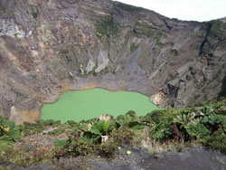
National Park Irazu Volcano
The Irazú is an active volcano; it is located in the Central Volcanic Mountain Range inside the national park, 30 km west from Cartago downtown. In 1569, in its slopes an indigenous town called Istarú was living there. This is the reason why they put this name to the volcano. Another important aspect is that the word Istaru means “place of herms” and it is full up with herms in the slopes of the volcano, so this may be another reason of its name.
It has 3432 altitude meters of altitude and its form is like an irregular cone. The summit of the volcano has several craters, which contain a green lake with a variable depth. It is the upper volcano of Costa Rica. It is easy to visit it from San Jose, through a direct road.
In its peak it is possible to see the both Costa Rican oceans, the Atlantic and the Pacific.
The National Park was recognized in 1955. It protects 2309 hectares around the volcano. The principal crater has 1050m of diameter and 300m of deep. The other crater has 690m of diameter and 100m deep also has a small lake. There is another crater that is starting to be settled.
Orosi
This town was named by a Huetar leader. He was living here by the conquest time.Orosí forms part of Costa Rica, it is about 35 km to the Southeast from San Jose, the capital. It has a population of 9000 inhabitants approximately. It is one of the few towns of the colonial times that have survived frequently earthquakes. It has one of the oldest churches in the country (century XVIII). It is inside a valley that has great extensions of coffee fields. In this town there is a club with great thermal water swimming pools.
Four kilometers to the south of the town, there are spas (with thermal swimming pools). Kilometers to the south, the highway is interrupt and begins the National Tapanti Death Hill Park. This park covers about 600 km and forms the northern region with an enormous extension of natural parks that extend until Panama.
National Tapanti Death Hill Park
It protects the Northern slopes of the Talamanca Mountain Range. It is one of the wettest places in the country. In the 2000 this park expanded 585 hectares and now it is part of the Death Hill.
Turrialba
It has an elevation to 650 ms on the sea level. Turrialba River follows Reventazon River and passes throw the Central Mountain Range. In 1991 a tremor stroked the country but Turrialba, with a population of 70,000 inhabitants didn’t suffer.
Turrialba has the best access for the white water springs.
Guayabo Arquaeological National Monument
It is 19 km northeast from Turrialba city. It is a bit of the Maya and the Aztec culture. In Guayabo the aqueduct system have served for more than 20.000 zone people.This site sometime was occupied by 1000BC and mysteriously abandoned in AD 1400.
Volcano Turrialba National Park
It is a passive volcano. It has 3328 m; years ago it was named by the Spanish colonizers by the name of White Tower.It was declared a National Park since 1955 and protects a radius of 2 km around the volcano. In the year 2001 the volcano showed its first activity sighs in 135 years.
Costa Rica: (506) 2233-5151
Fax: (506) 2233-5284
Fuera del horario regular y fines de semana: (506) 2257-4171
E-mail: [email protected]
Términos y Condiciones | Términos de Privacidad | Contacto | Nuestra compañía
El sitio para planear sus vacaciones en Costa Rica con información sobre alojamiento, tours, traslados, mapas de Costa Rica, principales ciudades y consejos para viajeros.
English Version