 Northern Lowlands
This zone is known for its seasonal rains, it has the problem that when rivers and lakes exceed all the land parts convert on wet swamps.
Farmers also work on land with corn, rice, beans and sugar cane. From the sugar cane comes the national alcoholic drink the “guaro cacique” This is the least visit region in all the country. This place is just visited for a daily tours not for remaining a hole week.
Vara Blanca
You have to go throw 2000 m to reach Vara Blanca. In the west side you can also visit the Poas Volcano and in the east the Barva Volcano. It is the perfect landscape to take pictures, high mountains filled of trees and green colors will describe this place perfectly. About 8 km you will find the La Paz River which will make you visit all its waterfalls around. This valley will join you with the Sarapiqui valley.
San Carlos Dock
It is famous for its huge sugar lands. This dock is important because you can navigate on its river. It is important to be very careful when driving because tired trucks stop to eat and park in the road aside the dock, so it’s important to be attentive.
Venado Caves
These caves were discovered in 1945 when a farmer felt into a hole in the ground and find himself underground. This area is made of soft, malleable limestone. The caves are home of spiders, bats and eye fishes. It’s important to take lights, helmets and a good shower afterwards. Outside the caves you will find a grocery store.
Upala
It is located 9 km south from Nicaragua’s border, in the northwestern corner. Upala is a small town with 15.000 people. This is the principal zone of cattle and rice. Many businesspeople visit this zone for exchanging ideas and commercialese. Years ago in Upala you could enjoy on Nicaragua's radio.
Nowadays people travels throw this road to get to Caño Negro and to Los Chiles.
Caño Negro Wildlife National Refuge
Years ago the streets were very bad for the scene, today they had increased. This refuge is 102 km square. From April to July, the park is closed for fishing; incidentally, very good prices of seafood will be in market. In the middle of the dry weather many birds visit and focus on the place. From January to March this place was for migratory birds. The Rio Frio defines the landscape. It is a cycle in which all people are accustomed to each monthly activity.
Los Chiles
It is 70 km north from the dock. The road is all surrounded by sugar cane; it is really close to the Nicaragua's border.
The principal activities of this zone are the farming and fishing. The fishing comes because this town is very near of the San Juan River.
This place was useful for the US military presence in 80’s.
It has a lot of tourism because it is a pass throw town.
The police is warned at day and night because Nicaragua’s people use to pass to Costa Rica.
Puerto Viejo, Sarapiqui
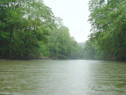 Sarapiqui is the canton number 10 in the province of Heredia. It is located near Rio Frio. The main agricultural activities in the region are coffee, maize, cocoa, citrus, bananas, palm trees, fruit trees and livestock. The southern Sarapiqui is located partially in the Forest Reserve Central Volcanic Range, in the National Wildlife Reserve Barra del Colorado, Braulio Carrillo National Park and Forest Protected Zone.
The Sarapiqui River has a history relevant in Costa Rica, for two primary reasons:
- It was the first transport road between Costa Rica and Europe.
- It played a very important role in the defense of national sovereignty, because the 10th April , 1856, the filibusters commanded by William Walker arrived to Costa Rica by the Sarapiqui River, where they fought the battle of Sardinal.
It has another attraction; La Virgen was a small town inside Sarapiqui. People say the Virgin used to appear to people begging her, so today it is a tourist place, were people come a prey for making the Virgin appear.
Although, it is a very nice place with different sight and activities.
- Rafting
- Kayaking
- Watching snakes.
South of Puerto Viejo de Sarapiqui
Thousands of banana plantations throw the Caribbean coast describe This zone is very accessible there are 3 overland routes of access:
1) For the traditional route or path of the heroes (Rod White), where you can observed the waterfalls San Fernando and La Paz, mountains, rivers and volcanoes.
2) On the road Braulio Carillo National Park crossing of the same name street, area of great exuberance and large landscapes.
3) San Carlos, where there are agricultural crops such as pineapple, palm and ornamental plants.
La Selva Biological Station
This place is well equipped with biological laboratories, experimental plots and an extensive library.
The main visitors are scientists and students.
It offers an inside hotel which is especially for the basic needs of this visitors, in other words it is like a refuge.
Heliconia Island
It is best known as oasis of serenity. It has the most beautiful garden in Costa Rica.
This place was created by Tim Ryan in 1992 a New York man which is an art and design teacher.
It has more than 2 hectares of tropical flowers, plants and trees. It has more than 80 species of helicons, more than 228 species of birds and four resident species of monkeys.
The tour will last 1 ½.
Rara Avis
It has 1335 hectares in a high altitude tropical rain forest.
This place was founded by Amos Bien an American biology student in 1977.
This reserve borders the Braulio Carillo National Park.
You can enjoy watching the birds and the waterfalls with 55 m high.
The accommodations of this place are lovely and rustic
Arenal Route
This route starts in Ciudad Quesada. This route is less traveled by tourists, they can travel throw the Inter-American street.
In this way you can see smoking volcanoes and sometimes pieces of tropical rain forests. This road also passes throw small towns as Tilaran and Nuevo Arenal. Important restaurants, luxury hotels and art galleries are around this trip. It has a cool climate because it is around Arenal Lake.
Ciudad Quesada- San Carlos
San Carlos is the tenth canton of the province in Alajuela. Its more important population is Quesada City, its principal town.
It has an extension of 3,347 km, which turns it to be the city of greater extension from 81 places in the country, surpassing in size to the provinces of Cartago and Heredia.
It was founded in 1911 and it consists of 13 districts.
1-Quesada
2-Florencia
3-Buenavista
4-Aguas Zarcas
5-Venecia
6-Pital
7-Fortuna
8-La Tigra
9-Palmera
10-Venado
11-Cutris
12-Monterrey
13-Pocosol
San Carlos is considered part of the countryside of Costa Rica.
It is the main town of the North Huetar Region. It was also conformed by others cantons in the north like Los Chiles, Guatuso, Upala, Sarapiqui and Tilaran.
Quesada city has 40.000 inhabitants. Ciudad Quesada has become the principal city of this entire zone that grouped the main governmental and commercial branch.
The principal reason of the importance of the city is because its really difficult to communicate and to get to the Central Valley.
This must mainly to the relatively uncomfortable passage that communicates to San Carlos with the Central Valley through mountains. A projected of a new highway is going to be made for relieve these difficulties.
La Fortuna
It is a relaxing place to stay for a few days. Waterfalls and hot springs surround this area.
If you want to go around the town thousands of tour operators will be happy to help you.
In 1968 was a calm town located 6km from the Arenal Hill.
In the 29 July 1968, Arenal had its first eruption after 400 years of sleeping.
In La Fortuna the old peasant vibe and the real culture is still alive.
Things have changed a little because today La Fortuna is in the first places of the tourist tours.
La Fortuna is the principal place to visit before coming to the Arenal volcano. It has well connected streets from different part of the country.
Arenal Volcano National Park
It is in the central part of the country, forming the Arenal Tilaran Conservation Area. The park surrounds the Arenal Volcano , which is the most active volcano of the country. An arenal lake has the largest hydroelectricity project in the country because of the Arenal Dam Lake.
The park also contains a second volcano named Chato,
This crater contain a lagoon, it is also called Chato’s Mount.
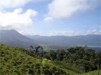
Arenal Lagoon Area
It is located 18km west in la Fortuna. This lake is the largest and the big one in the country with 88 sq km. It was formed by an enlarging existing lake with the same name by the completion of a dam in 1979. It is located near the Arenal Volcano and the Monteverde cloud forest.
Lake Arenal is the key driver in a nationwide hydroelectric project that currently produces the majority of electricity for the entire country. Water depth generally varies between 100 and 200 feet. The communities of "old" Arenal were submerged by the expanded lake.
From November through April the dependable strong winds attract windsurfers to its western end.
Real estate around Arenal Lake region is exploding, perhaps it is due to the high prices of the beach front and of the ocean view.
Around the lake there are two species of fish, the Machaca and the Bass. Bird’s species are normally the same, the hummingbird and the woodpecker.
Costa Rica: (506) 2233-5151
Fax: (506) 2233-5284
Fuera del horario regular y fines de semana: (506) 2257-4171
E-mail: [email protected]
Términos y Condiciones | Términos de Privacidad | Contacto | Nuestra compañía
El sitio para planear sus vacaciones en Costa Rica con información sobre alojamiento, tours, traslados, mapas de Costa Rica, principales ciudades y consejos para viajeros.
English Version